The
application of GIS to the archaeological mapping of Afghanistan
offers an excellent means of evolving a new platform for synthesizing
and interpreting data, for assessing and monitoring the preservation
of sites, and for the eventual collection of new data. In conjunction
with other Central Asian GIS projects, it can also form a tool
with which to study historical human geography within and across
the region, and themes such as the evolution of settlement patterns
and cultural interactions across the Iranian plateau and Central
Asia. The GIS described in this section is a first step in this
direction, containing over 2000 sites and associated data sets,
derived from the Archaeological Gazetteer of Afghanistan [Ball
1982], the French surveys in eastern Bactria [Gardin 1998; Lyonnet
1997; Gentelle 1989] and other sources.
From
maps and catalogs to GIS
The two main sources of archaeological data digitized were the
Gazetteer and data from the plains east of the Kunduz river, which
were the object of an extensive regional survey by a French team
in the 1970s. Geographic and cartographic "base map"
data sources include publicly available vector data such as National
Imagery and Mapping Agency (NIMA) Vmap1 and current data from
Afghanistan Information Management System (AIMS), as well as raster
data such as 3-arcsecond Digital Elevation Models (DEMs). Of great
potential are georeferenced 1:100,000 and 1:50,000 Soviet military
topographic map sets, which not only allow for precise localization
of known sites, but the addition of hundreds of undocumented sites,
which are marked as mounds on these maps (Fig. 1).
The
Gazetteer data were digitized by scanning the site catalog, performing
text recognition, and creating a single database record for the
text of each catalog entry, including its detailed description,
periodization, bibliographic references, etc. The coordinates
given for each site were extracted automatically into separate
database fields and converted into decimal degree format. Because
seconds are not provided in these coordinates, the resulting calculated
decimal degree coordinates significantly exaggerate their geographical
precision (since the geographical range of sites within one minute
could amount to a difference on the ground of over a kilometer).
Entries in the Gazetteer spanning more than one geographical minute
were averaged into one decimal degree coor dinate . Averaged coordinates
are mainly the groups of sites subsumed by Gardin into one catalog
entry in the Gazetteer, but most of these were individually localized
much more precisely in the digitization of more data from the
original survey maps of the Gardin team. Such precise localizations
are necessary in areas crowded with sites, which sometimes even
bear the same names.
The
separate publications of the latter data formed the second main
source for the GIS. In three seasons (1974-5-6) of survey in the
Dasht-i-Qala plain, approximately 200 square kilometers
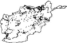
Fig.
1. Sites mapped in the GIS.
were
surveyed, recording 349 sites, while one season (1977-8) of extensive
survey across some 1,500 km. recorded 474 sites. The GIS in its
present form contains localizations only of the sites of the extensive
survey (mapped in Fig. 2); however the digitized site database
includes records for the remaining 226 sites in the Dasht-i-Qala
plain.
Data have so far been entered in the database for these fields:
number (sometimes with sub-number identifying letter); Ball number
and subnumber identifying letter (A, B, C, etc.); a 'D number'
for sites in the Dasht-i-Qala plain (to distinguish these sites,
which are numbered in a different sequence); name when given;
the designated geographic area, sectors, subsectors, and sub-subsectors,
and finally the presence-absence fields for the different ceramic
groups at each site. The complex set of fields used for coding
the ceramic finds at each site is a function of the notation of
periodization used by Gardin [1998], which generally refers to
degrees of certainty of attribution (and which is not always the
same as the identifications in Lyonnet 1997).1 Exclusive of a
subset of sites in the Dasht-i- Qala plain, the present form of
this subset of the digitized site database thus contains 695 complete
records.
Not
yet included in the database is the full narrative description
for these sites, which generally contains a measurement and descriptive
localization (itinerary). No coordinate locations are given in
this site catalog, but in the localization in the GIS through
the use of the original maps used on survey, coordinates were
identified within a estimated precision of hundreds of meters
for most sites (and the descriptive data could be used for even
greater accuracy in localizing sites with larger scale maps).
These original survey maps were a set of 1:100,000 scale Soviet
topographic maps and corresponding photocopies marked with the
field data from the survey.2 Some of the maps were themselves
large-format black and white photocopies or color reproductions
of varying quality. The photocopies of sections of these maps
corresponding to sectors or portions of sectors described in the
survey synthesis were marked with all the sites recorded on the
survey, labeled with the survey number. In the case of larger
sites a sketch of the extent and shape of sites was where one
'x' or a small circle identifies a series of sites, a point was
entered at the center of the shape (Fig. 3).
Even
in rare cases where exact locations of individual sites were not
indicated, the error can be estimated to be under a kilometer,
and in most cases the accuracy of the coordinates
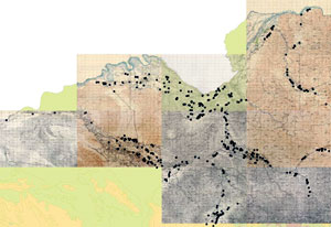
Fig. 2. Sites of eastern Bactria (excl. Dasht-i- Qala plain).
digitized
in this fashion are probably better or even similar to the total
error range of a standard (non-survey) GPS receiver. The maps
published in the survey synthesis were consulted during the digitization
process, but because of their schematic nature, the sources described
above were given preference in making all geographic determinations.
Desiderata for database development
Data from sources not entirely included in the Gazetteer, such
the Soviet-Afghan mission [cf. map in Sarianidi 1976], as well
as unpublished ones, also need to be incorporated. The development
of the database also requires reorganization of the material which
has already been digitized. Database entries from the Gazetteer
contain entire texts of catalog entries in one field, with the
exception of coordinates. While this text field can be queried
(e.g. for the string "Bronze Age" or "Kushan"),
including spatial queries, the ability to carry out more complex
queries on the Gazetteer data is limited, and each of these entires
should be converted into database fields, for which they are essentially
already structured.
Separate
database fields are important for bringing the data on a uniform
level with other site databases, as well as for analysis. This
is particularly relevant for periodization and site size, but
other fields contain data of significance for interpretation —
for example the fieldwork type (excavation, survey) could be compared
with new data on intensity of survey (scale of intensity, quantified
in terms of time, surface area collection size, etc.). The incorporation
of a structured, site-by-site bibliographic database is likewise
an important aim. Finally, the inclusion of the site plans, and
the creation of a photographic database, are goals for developing
the database as a tool to track the state of preservation of sites
and collections. A unified database form should ideally encompass
a spectrum of formats from fields which contain discrete quantifiable
data which needs to be formalized for analytical purposes (spatial
queries, etc.), to more descriptive fields which can contain miscellaneous
descriptive information, notes etc.
Finally,
without groundtruthing, inaccurate or imprecise localizations
can only be somewhat ameliorated by consulting original archaeological
publications and comparing cartographic sources. The correction
of geographic localizations can also sometimes be achieved using
higher quality cartographic sources, and the Soviet topographic
sets also record many mounds which have not been examined or identified,
but which are in many cases archaeological sites. An important
task would be creating a point feature set from all mounds marked
on these maps, identifying those which are documented in the literature,
and taking the remaining mounds as a basis for future documentation
(point sets can simply be downloaded into a GPS and then navigated
to as waypoints).
Potential
applications
Over twenty years ago, after collecting and reviewing most of
the existing archaeological data from Afghanistan, Ball offered
an assessment of the work to be done in the Introduction to the
Gazetteer [1982, p. 20]: "Generally ... the need for survey
– and survey of a systematic and organized sort – appears
to be paramount. In many ways, surveys can answer more questions
than excavation." While a GIS database including unpublished
material and material published since the Gazetteer offers new
possibilities for the interpretation of existing archaeological
data, and for remedying some of the many imbalances in our knowledge
of Afghanistan's past, the need for survey can only have grown
during the tragic events since the time of Ball's judgment.
Many
factors may of course limit the logistical feasibility of carrying
out any kind of fieldwork in Afghanistan for years to come. Nevertheless,
the return of stability in certain regions of the country has
made it possible for archaeologists to renew fieldwork and even
undertake some limited excavations [Tarzi 2004; Franke-Vogt n.d.],
and several important discoveries have already been made [Lee
and Sims-Williams 2003; Grenet, Lee, and Ory, n.d.]. This work,
undertaken by scientists hazarding the dangers of travel in the
countryside of Afghanistan, follows a series of spectacular discoveries
over the past decade which were sadly made in undocumented and
illicit circumstances, such as a group of Bactrian socio-economic
documents, which have unveiled what was essentially an unknown
language [Sims- Williams 2001]; new inscriptions, which have settled
questions of chronology that kept generations of scholars busy
with speculation [Falk 2001]; large numbers of Kharoshthi birch-bark
scrolls, which proved to be the earliest Buddhist manuscripts
known [Salomon 1999]; the Mir Zakah hoard, "one of the largest
coin deposits attested in the history of mankind" consisting
of "three to four tons of gold, silver and bronze coins"
[Bopearachchi 1999, p. 109], as well as a host of other material
which has
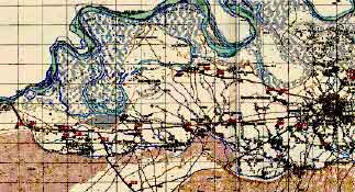
Fig. 3. Sites in the area of Imam Sahib, near the Amu-darya.
surfaced
on the antiquities market, such as Bronze age funerary material
from Bactria.
The appearance of such a wealth of material in a such a chaotic
fashion only underscores the need to design a GIS database to
accomodate new data, and when and where possible, from new surveys,
which offer perhaps the best possibility for effectively documenting
a large amount of data before it is lost. Some possibilities in
this direction include designing the database to accommodate data
from different survey techniques; adapting a ceramic database
template for surface collection; establishing a baseline for evaluating
(or indeed, if possible, quantifying) the current preservation
of sites, against which historical and future assessments can
be measured; establishing a protocol for collecting photographic
documentation (for example, following relatively simple methods
which will make it possible for the images to be post-processed
for photogrammetry); creating a general database template which
can be distributed to archaeologists and others working in the
field, and so on. Obviously, a GIS of Afghan archaeology should
be designed with such potential applications in mind, and should
be open to international collaboration of the broadest scope.
